New process allows scientists to track glacier changes via satellite
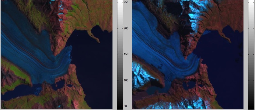
Florida Institute of Technology mathematics assistant professor Dr. Nezamoddin N. Kachouie, along with his collaborators, has developed a method for tracking and estimating mountain glacier change via satellite images. Ground based measurements of the terminus point – the point where the glacier meets water or ground – are available for some glaciers. However, ground measurement requires scientists to physically travel to mountain glaciers, but many of them are inaccessible or extremely difficult to visit, which limits the data to which researchers have access.
Tracking changes in mountain glaciers is an important part of studying climate change because their extent is used as an indicator of climate. In addition, mountain glaciers often serve as important water resources for people living in nearby geographic areas. Because of the limited number of ground observations relative to the number of mountain glaciers, satellite-based estimation of mountain glacier change is very useful. Kachouie’s team set out to try to make it easier to track the changes to these more remote mountain glaciers by using images available through Landsat, a collection of space-based satellite images, which have been publicly available since 2009, but go back as far as the 1970s.
As part of their research, which will be published in the March 2015 issue of IEEE Transactions on Geoscience and Remote Sensing, Kachouie and his collaborators developed a suite of techniques that allows the research team to locate terminus points on Landsat images of mountain glaciers, track the changes over time by comparing these points and evaluate them using a variety of mathematical and statistical methods, which they also developed.
“Basically, this is a hybrid method — a combination of image processing, statistical analysis and pattern recognition techniques — to address an important problem,” Kachouie said. “The approach has a reasonable estimate and demonstrated promising results. It can be potentially extended to predict what we may expect to see in the future if the same trend continues.”
Understanding the effects of climate change on glaciers is important to the lives of people. “If, because of the change in the temperature, we have an abrupt melting process in a short amount of time, there are some consequences we need to deal with,” Kachouie said. “If, for example, the recession of the glacier has been expedited, we expect increased chances of flooding in the short term, and loss of water resources in the long term. It helps to have plans for consequences in the short, mid and long term.”
Tackling this complex problem required an interdisciplinary research team. Kachouie worked alongside an epidemiologist, an earth and planetary scientist, and a statistician to complete this research. “This is a multidisciplinary problem and needs to be addressed by a team with multiple different majors, disciplines, and expertise,” he said.
The team plans to apply this method to more mountain glaciers, including those where ground measurements are unavailable, in order to estimate mountain glacier change in the past. It may also help predict how glaciers will change in the near future and which geographic areas might be most affected if the current trend of glacier change continues.